Historic Environment Records evolved from the County "Sites and Monuments Records" that developed in the 1970s and 1980s, often pioneering the use of the emerging database technologies of the day. These "SMRs" in turn owe their origins to the records collected by the Ordnance Survey ("OS"), driven by O.G.S. Crawford in the 1920s and 1930s, which used a systematic method of cataloguing sites on index cards and 1:10,000 (or earlier 1 mile=6") map sheets.
This fascinating guide to the Ordnance Survey records was recently found in the records of the Somerset Archaeological Society. It was presumably distributed by Ordnance Survey whenever they sent out copies of the cards.
THE ORDNANCE SURVEY'S ARCHAEOLOGICAL RECORDS
A. INTRODUCTION
The records consist of 8" x 5" index cards ('Record Cards') which give information about antiquities, and 1:10,000/1:10,560 maps ('Record Sheets') on which the sites of the antiquities are marked. The Record Card is described under B, the Record Sheet under C, and under D is a Glossary of the common abbreviations used on both cards and sheets.
B. THE RECORD CARD
The component parts of the current record card are as in Fig 1 below. There were some differences on older cards though the same purposes were served. The main differences are noted in the explanation.
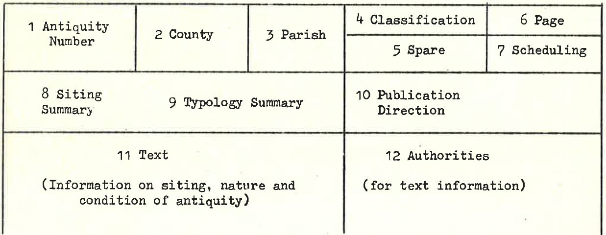
Fig 1
1. ANTIQUITY NUMBER
This consists of the National grid number of the 1:10,000/10,560 sheet within which the antiquity falls (eg TQ 37 SW) plus a serial number within that sheet (eg TQ 37 SW 4), and used in its full form identifies the antiquity uniquely. The serial numbers are simply allotted consecutively as each record is compiled, and consequently have no bearing on where the site falls within the sheet, nor any typological significance.
There can also be subsidiary number (eg TQ 37 SW 4.1), used when a component part of an antiquity is allotted a card to itself.
There can in addition be a 'Miscellaneous Information card' for any sheet. This gives very brief information on items of marginal interest which fall on the sheet, and there is only one such card (or card series) for each sheet. It is identified by the sheet number plus a bracketed 'M' (e.g. TQ 37 SW (M)).
2. COUNTY
The name of the county at the date of the last entry. Abbreviations are those adopted by the Ordnance Survey.
3. PARISH
The name of the civil parish at the date of the last entry.
4. CLASSIFICATION
Abbreviations of the archaeological period(s) within which the subject(s) of a card falls, and also abbreviations to show that the period is unestablished, or that the subject of the record not an antiquity (within OS specification). The abbreviations and their meanings are given in the glossary under D below.
5. SPARE
Reserved for future extension of the classification.
6. PAGE NUMBER
The card side number whenever the record extends over than one card side.
7. SCHEDULING
The letter 'S' is entered when the antiquity is scheduled as an Ancient Monument by the Department Of the Environment. On old cards, scheduling was mentioned as text information and authorized. 'S's have not been comprehensively entered, and the lack of an 'S' is no guarantee that the antiquity is unscheduled.
8. SITING SUMARY
A Map-reference of the latest established site or find-spot of the antiquity, whenever this is known to at least a six-figure accuracy (i.e. to within about 100 metres). When siting is less precisely known, the name of the town, village or other place associated with it is entered with a four-figure reference. On old cards the siting summary was in the space serving for both purposes.
9. TYPOLOGY SUMMARY
A brief summary of the (latest established) nature of the antiquity in modern terms, taken from the information recorded, and accounting for each item in the record which has a different period classification.
10. PUBLICATION DIRECTION
Direction (for internal use) as to whether the antiquity is to be published on standard basic scale map, and if so the form the name should take and the type character to be used.
11. TEXT
The information necessary to demonstrate the siting, nature and condition of the antiquity (or to give as much as possible towards those ends), taken from whatever sources provide it, these sources being shown in the adjoining 'Authorities' part - see 12 below. The information can be entered either 'objectively' (i.e. by separate precis from each source) or 'subjectively' (i.e. by a single entry compiled from as many sources as are necessary), or by a mixture of these methods.
Normally the record will start with the objective entry of an Ordnance Survey publication. In subjective entries references are given to the various sources by use of the author's name or bracketed numbers. In objective entries the whole of the text is attributed to a single authority. The recorder can himself make interpolated comments, or even a separate entry of his own opinions. Field reports are always attributable to the Field Investigator himself unless otherwise stated.
12. AUTHORITIES
Each authority (source) consulted and used is given a number. With objective recording this number, with the title of the authority concerned, is positioned opposite the top line of the relevant text entry. With subjective recording, the numbers and authority titles are listed in sequence without interval, the first being opposite the first line of the text entry.
Secondary authorities (or sub-references) are lettered in lower case, and this lettering is in sequence throughout any one record (i.e. letters are not repeated even though under a different primary authority). Secondary authorities are only noted when they make necessary contributions but do not need to be used as primary authorities; it should therefore be appreciated that the primary authorities contain references which are not noted on the record cards. Secondary authorities may in fact have been consulted by the recorder, but the implication of the identification by lower case letters is that they have not. The recorder responsible for entries is identified by R1, R2 etc, with his initials and date, entered opposite the line of the last entry. The Field Investigator is similarly identified by F1, F2 etc, entered opposite the top line of his field report (and covering any recording between that entry and the last recorder's ascription). In the field reports informants are usually treated as secondary authorities, but they can be given separate entries as primary authorities. On old cards Recorders were designated 'OR' and Field Investigators FI and full names were given.
References dealing with relevant typology, but not with the specific antiquity which is the subject of a record, are mentioned in the text, not the Authorities compartment.
13. ILLUSTRATIONS
Illustrations are mounted on separate 'Illustration Cards' numbered in the same way as the record cards. The illustrations may be air photographs, ground photographs, diagrams, plans, or surveys, and they are folded to size if necessary. The photographs do not reproduce.
All Archaeology Division field surveys are ultimately included as illustrations, but there is delay in annexing them, as they have to pass through drawing stage (for the production of new OS maps) before becoming available.
C. THE RECORD SHEET
An example of the current record sheet marking is given in Fig 2 below. The essential ingredients are:
a. a convention marking the site
b. the antiquity number
c. a typological summary.
There were some differences on older record sheets though the same purposes were served. The main differences are noted in the explanations.
 Fig 2 (Examples fictitious)
1. SITE MARKING
Various markings are used, and on the master copy record sheets different colours are also employed for further refinement. But the main purposes of the record sheets are to serve as indices to the record cards and to record the sites of antiquities topographically, and these purposes are just as well served by monochrome copies. All that is lost are certain nuances of siting and typology useful for quick reference but fully covered on the record cards.
The markings are: Crosses, Published detail, Sketched outline, Bands, Linear markings and Broken linear markings.
The following explanations deal with their monochrome fom only, so more than one meaning sometimes attaches to a single convention. The separate implications however can be readily clarified by reference to the record cards.
Crosses
a. Accurate find-spot or site, whether or not extant (Ex 5).
b. Inaccurate site or find spot (Ex 1).
c. Centre of an extensive antiquity when the outline cannot be properly recovered (Ex 11).
Published detail
This is normally left to stand by itself (Exs 9, 2.1) but it can be shaded or blocked in when it is necessary to distinguish it from adjacent features (Ex 12).
Sketched outline
This is used in preference to a cross for large antiquities which are not published on the record sheet (Ex 10).
Bands
a. Defining a group of antiquities treated on a single record card (Ex 4).
b. Defining the known outline of a feature or site with no perimeter feature (eg a DMV) (Ex 2).
c. Defining the area within which an antiquity occurs, when that area is already defined by published detail, such as hedges (Ex 7).
Linear Markings
The course of a linear antiquity; including extensive enclosure banks etc such as park pales (Exs RR46, Lin 21).
Broken linear markings
The course of a linear antiquity when uncertain (Ex RR46).
2. ANTIQUITY NUMBERS
A plain number in a circle is the number allotted to the record card. It should be noted that to identify the antiquity uniquely the sheet number must be added to this (Exs 1-12).
A decimalised number in a circle refers to a subsidiary record (cf B 1 above) (Ex 2.1).
A smaller number in brackets applies to miscellaneous information (cf B 1 above) (Ex (1)).
The entry of a number in the east margin of the sheet conveys that the antiquity concerned probably falls on that sheet but cannot be sited with any accuracy (Exs 6, 8).
A full number in brackets entered in the margin adjacent to the marking of an antiquity which extends over the edge shows that the card is allotted to the adjacent sheet (Ex (TQ 37 NW6), in north margin).
Linear antiquities are numbered according to a separate Linear system, which is not controlled by sheets. Roman Roads are given the Margary numbers ('Roman Roads in Britain'), otherwise the numbering system is the Ordnance Survey's. Linear numbering is entered on the sheets in brackets, normally along the axis of the Linear (Exs RR46, Lin 21).
3. TYPOLOGICAL SUMMARIES
These are similar to the typological summaries on the record cards (cf B9 above), though they need not be exactly the same. They are entered on the sheets for convenience and as a safeguarding connection with the record card, additional to the number.
D. GLOSSARY OF ABBREVIATIONS USED ON THE ORDNANCE SURVEY'S ARCHAEOLOGICAL RECORD CARDS AND SHEETS
This is not comprehensive, but should account for the majority of the abbreviations which might be puzzling. It does not account for the book title abbreviations used in the 'Authorities' part of the record card, which should be easily understood, nor for the initials of the compiling staff (see B 12 above) Which are irrelevant to the understanding of the records.
| ABBREVIATION |
MEANING |
AREA OF OCCURRENCE
(Number of component
part of record card,
as in Fig 1, or 'S') |
| AAO |
Assistant Archaeology Officer |
12 |
| Acc No |
Museum Accession number |
11 |
| Accn No |
" " " |
11 |
| AO |
Archaeology Officer |
12 |
| " |
Archaeology Division |
12 |
| AP |
Air photograph |
11, 12 |
| AS |
Anglo-Saxon |
9, 11, S |
| AT |
Antiquity Tpe character |
10, 11 |
| Authy |
Authority |
11 |
| BA |
Bronze Age |
4, 9, 11, S |
| BM |
British Museum |
11 |
| C or c |
Century |
9, 11 |
| c |
Circa |
11 |
| Corr |
Ordnance Survey arch. correspondent |
12 |
| Corr 6" |
Correspondent's annotated 6" sheet |
12 |
| Crem |
Cremation |
9, 11 |
| DA |
Dark Ages |
9, 11, S |
| DOE |
Department of the Environment |
12 |
| DMV |
Deserted medieval village |
9, 11, S |
| diss |
Dissolved (monasteries) |
11 |
| EBA |
Early Bronze Age |
9, 11, S |
| EI |
Early Industrial |
4, S |
| EIA |
Early Iron Age |
9, 11, S |
| Ewk |
Earthwork |
9, 11, S |
| Ed |
Editor |
11, 12 |
| Ed |
Edition |
11, 12 |
| F1, F2 etc |
First, second, etc OS Arch fd investigator |
12 |
| fd |
Found |
11, S |
| " |
Founded |
11, S |
| GP |
Ground photograph |
11, 12 |
| GS |
Gil Sans type character |
10, 11 |
| GT |
German Text type character |
10, 11 |
| HHR |
DOE Historic Houses record |
12 |
| IA |
Iron Age |
4, 9, 11, S |
| IAM |
DOE Inspectorate of Ancient Monuments |
11, 12 |
| Inf |
Informant, or Information from |
12 |
| Inhum |
Inhumation |
9, 11 |
| LB |
Lutheran Black type character (Obs) |
11 |
| LB |
Long Barrow |
11 |
| LBA |
Late Bronze Age |
9, 11, S |
| Lin |
Class name for linear feature other than a Roman road |
11, S |
| (M) |
Miscellaneous Information card |
1 |
| MBA |
Middle Bronze Age |
9, 11, S |
| Md |
Medieval |
9, 11, S |
| Me |
Mesolithic |
4, 9, 11, S |
| MHLG |
Ministry of Housing & Local Govt (Obs) |
12 |
| MOW |
Ministry of Works (Obs) |
12 |
| MPBW |
Ministry of Pub Works & Buildings (Obs) |
12 |
| Mus 6" |
Annotated Museum 6" sheet |
12 |
| NAT |
Non-antiquity type character |
10, 11 |
| Ne |
Neolithic |
4, 9, 11, S |
| NMR |
National Monument Record |
11, 12 |
| NR |
Non-Roman Type character |
10, 11 |
| Occ |
Occupation |
9, 11, S |
| ONB |
Ordnance Survey 'Object Name Book' |
11, 12 |
| OR |
Office Recorder (OS staff) (Obs) |
12 |
| OS |
Ordnance Survey |
11, 12 |
| P |
Continue to publish in same form |
10 |
| Pa |
Palaeolithic |
4, 9, 11, S |
| Poss |
Possible |
9, 11, S |
| PN |
Post-Norman |
4 |
| PR |
Post-Roman |
4 |
| Prob |
Probably |
9, 11, S |
| Pte 6" |
Private 6" sheet, annotated |
12 |
| R1, R2 etc |
First, second, etc OS Arch recorder |
12 |
| Rec 6" |
Records 6" (obsolete annotated sheet) |
12 |
| Rems |
Remains of |
9, 11, S |
| RB |
Romano-British |
9, 11, S |
| R & F |
Ridge and furrow |
9, 11 |
| Ro |
Roman |
4, 9, 11, S |
| RR |
Roman Road with Margary number |
1, 9, 11, S |
| RRX |
Roman Road without Margary number |
1, 9, 11, S |
| S |
Scheduled by IAM (qv) |
7 |
| SS Rev |
OS Small Scales reviser |
12 |
| S/Svyr |
Senior Surveyor (Archaeology Division) |
12 |
| TI |
Times Italic type character |
11 |
| TU |
Times Upright type character |
11 |
| U |
Period unestablished |
4, 9 |
| X |
Not an antiquity |
4 |
| X |
Do not publish on standard maps |
10 |
| |
|
|