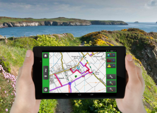
CAMS Mobile allows CAMS to be accessed in the field.
- Record details of works in just a couple of screen taps
- Plot Furniture and Issues on the map using GPS
- Photograph items using the in-built camera
- Record Jobs, Routes and Land using intuitive forms
CAMS Mobile gives you:
- Live data collection in the field
- Portable, lightweight smartphone / tablet
- Fast, accurate GPS
- Fast, simple recording of data
- Mapping and intuitive forms
- In-built camera
- Seamless data synchronization
CAMS Mobile is ideal for:
- Carrying-out condition surveys
- Ad hoc recording of work
- Information resource in your pocket
- Populating asset registers
- Recording issues
- Recording details of site visits

A touch of a button synchronizes the data on your device with your CAMS. So you are always working with a copy of your live data. You can synchronize your data anywhere there’s a Wi-Fi or 3G connection, there’s no need to bring the tablet into the office to get your data. And no need to worry about surveying in areas where there’s no signal.