Public Open Space Management - the Greenspace Project
Access to open space, particularly accessible natural greenspace, is recognised as having an important part to play in the health and wellbeing of communities. Natural England and the Countryside Council for Wales formulated a toolkit to assist local authorities with auditing and assessing provision of accessible natural greenspace. Greenspace Scotland have formulated a methodology for use in auditing open space in Scotland based on the PAN65 Open Space classification schema. Guidance on other types of open space is also available through related initiatives such as the National Playing Field Standard. Exegesis have worked for eight local authorities in Scotland and Wales on such projects.
In addition to the identification and classification of sites, Exegesis have developed an approach for assessing access provision which involves calculating the distances to/from sites along lines of communication (roads, tracks, rights of way, etc) sourced from local authority datasets and the Ordnance Survey. This can then be combined with population data from the most recent census to provide statistics regarding numbers of people with sufficient access to open space, and locations where the provision falls short according to the defined national criteria. Furthermore, the data can be re-analysed to model ‘what-if’ scenarios to study the effects of new developments and/or changes to the transport network.
Exegesis offer the following related services:
- Greenspace and/or Open Space Audit – identification and classification of spaces using existing digital datasets
- Greenspace and/or Open Space capture – where gaps in existing datasets would affect results, it is possible to use aerial photography and datasets such as the OS Mastermap to identify and capture additional sites
- Validation – field survey can be used to validate desk-based assessment and provide additional information including photographs of sites which can be used to support auditing activities. This is also essential for assessing whether sites meet certain criteria for inclusion, for example compliance with the NPFS standard.
- Access provision analysis – using network analysis techniques, it is possible to calculate the distances people live from their nearest greenspaces, essential for assessing compliance with defined national criteria
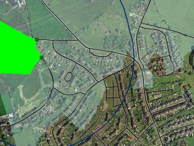
Example of greenspace access mapping, showing an area of designated public greenspace (light green), with access points to the greenspace (dark green boxes) and the roads network (black lines). The blue line joins points of equal travel distance from the greenspace, and the shaded area represents those houses within the 400 m target distance of the greenspace, as measured along the road network.