Feasibility study for the development of a Connectivity Assessment Tool for Kent and Nord-Pas de Calais Client: Kent County Council exeGesIS were contracted to undertake a feasibility study on the development of a tool to assess functional ecological connectivity. This involved an assessment of user needs, a review of the available methods and approaches, a stakeholder workshop to identify the preferred options and the development of a functional specification. ... read more November 2011. Categories: Desk research Ecology GIS Habitat connectivity Workshop
Marine intertidal habitat review and assessment Client: Countryside Council for Wales exeGesIS analysed Marine Intertidal Phase 1 data for the whole of Wales using the standard CCW Conservation Assessment Protocol and a bespoke database application in Microsoft Access. This application reads and analysis the original survey data to produce reports containing the results, measured against SSSI selection criteria. ... read more February 2010. Categories: Data analysis Database Desktop application Ecology GIS Marine data
Habitat inventory data capture and processing Client: Natural England / English Nature 
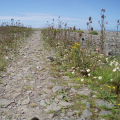
exeGesIS has produced habitat inventories for coastal vegetated shingle, saline lagoons, grassland and upland Biodiversity Action Plan (BAP) habitats. These involved collating spatial data, capturing paper-based data, aerial photograph interpretation, ground truthing and processing available data to create standardised national datasets. ... read more January 2010. Categories: Biodiversity Ecology Habitat inventory Spatial data capture
Scoping Study and Pilot Survey of Upland Habitats Client: National Parks and Wildlife Service This project involved the collation and evaluation of a suite of ecological datasets, the production of an indicative map of upland habitats, an investigation of upland field data collection options, and capturing all survey data to GIS. ... read more September 2009. Categories: Data analysis Data processing Desktop application Ecology GIS Habitat map Habitat survey In-field technology Spatial data capture
Develop Interactive mapping for 'Mapping European Seabed Habitats' Client: Joint Nature Conservation Committee The MESH project gathered large amounts of marine habitat data from a number of European partners. These were standardised to produce a unified seabed habitat map using the best data available for each area. We produced web mapping for this project using open source Mapserver software. ... read more March 2007. Categories: Data processing Ecology Habitat map Marine data Web map
Stone curlew disturbance analysis Client: Cambridge University, the RSPB and English Nature exeGesIS used a GIS model to predict the effects of disturbance from visual stimuli on nesting stone curlew Burhinus oedicnemus. This was used to map and graph the effects of different disturbances on the birds and identify the best areas to undertake habitat management to encourage nesting. ... read more February 2006. Categories: Data analysis Ecology GIS Viewshed analysis