Link to site root
  • Home
  • Software
    • cloudscribe components
    • MapInfo GIS
      • MapInfo Training
      • MapInfo Extensions
        • Map Templates
        • Constraint Checker
        • Address Finder
        • Environments and Gazetteers
        • MapLink
        • LibraryLink
    • ESRI ArcGIS
      • GISquirrel
      • MapLink
      • LibraryLink
      • ArcGIS Training
    • QGIS
      • QGIS Extensions
    • GISquirrel
    • CAMS Access Management
      • CAMS Desktop
      • CAMS Pro
      • CAMS Mobile
      • CAMS Web
      • CAMS Support
      • CAMS Training
      • CAMS Services
    • CMSi Site Management
      • Software for Site Management
      • CMSi Solution
      • CMSi for BNG
      • CMSi Benefits
      • CMSi Modules
      • CMSi Community
      • CMSi Training and Webinars
    • HBSMR Historic Environment
      • HBSMR Features
      • HBSMR Extensions
        • HBSMR Consultations
        • HBSMR Themes
        • HBSMR Web & API
        • HBSMR Gateway
          • HBSMR Gateway Costs
      • Services
        • Custom Heritage Solutions
        • Hosting HBSMR
      • HBSMR clients
      • HBSMR downloads
      • Documentation
      • HBSMR training
      • Local Heritage List Platform
    • FlyMapper
      • FlyMapper Web
      • FlyMapper Mobile
      • FlyMapper Community
    • LibraryLink
      • How LibraryLink Works
      • LibraryLink Training
      • LibraryLink SDK
    • MapLink
    • Marine Recorder
      • Marine Recorder downloads
  • Services
    • Training
      • QGIS Training Courses
      • ArcGIS Training Courses
      • MapInfo Training Courses
      • CMSi Training & Webinars
      • CAMS Training
      • LibraryLink Training
      • HBSMR training
    • GIS Consultancy
      • Data capture and cleansing
      • Data processing and translation
      • Lidar Processing
      • Spatial Data Analysis
      • Map Production
      • Bespoke GIS Tools
      • GIS Software and GI Systems Consultancy
    • Application Development
    • CMS Websites
    • Web Mapping
    • Application Hosting
    • Ecology
      • Ecological data management
      • Conservation Management Planning
      • Ecological field survey
    • Countryside Access
      • Public Path survey
      • Digitising and data processing
      • Public open space management
      • Gradient and accessibility mapping
    • Charities
      • GIS packages
      • Free Spatial Data
      • Discounted Training
      • Discounted Consultancy
      • Hidden Catch?
  • Portfolio
  • About Us
    • Contact
    • Staff and Partners
    • Selective Client List
    • Quality Management
    • CCS Supplier
    • How to find us
    • Where to stay
    • Knowledge
  • Opportunities
  • Software
  • CMSi Site Management
  • CMSi Modules
  • Adaptive Management Planning
  • cloudscribe components
  • MapInfo GIS
    • MapInfo Training
    • MapInfo Extensions
      • Map Templates
      • Constraint Checker
      • Address Finder
      • Environments and Gazetteers
      • MapLink
      • LibraryLink
  • ESRI ArcGIS
    • GISquirrel
    • MapLink
    • LibraryLink
    • ArcGIS Training
  • QGIS
    • QGIS Extensions
  • GISquirrel
  • CAMS Access Management
    • CAMS Desktop
    • CAMS Pro
    • CAMS Mobile
    • CAMS Web
    • CAMS Support
    • CAMS Training
    • CAMS Services
  • CMSi Site Management
    • Software for Site Management
    • CMSi Solution
    • CMSi for BNG
    • CMSi Benefits
    • CMSi Modules
    • CMSi Community
    • CMSi Training and Webinars
  • HBSMR Historic Environment
    • HBSMR Features
    • HBSMR Extensions
      • HBSMR Consultations
      • HBSMR Themes
      • HBSMR Web & API
      • HBSMR Gateway
        • HBSMR Gateway Costs
    • Services
      • Custom Heritage Solutions
      • Hosting HBSMR
    • HBSMR clients
    • HBSMR downloads
    • Documentation
    • HBSMR training
    • Local Heritage List Platform
  • FlyMapper
    • FlyMapper Web
    • FlyMapper Mobile
    • FlyMapper Community
  • LibraryLink
    • How LibraryLink Works
    • LibraryLink Training
    • LibraryLink SDK
  • MapLink
  • Marine Recorder
    • Marine Recorder downloads

Adaptive Management Planning


Adaptive Management Planning

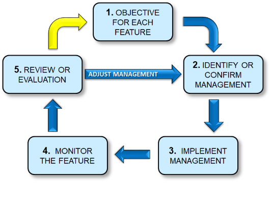
CMSi is designed to allow you to fully implement the adaptive approach to the management of your sites. Indeed the development of CMSi has been integrated with the development of the approach in the UK.

To learn more, talk to other users or see CMSi in action, please contact us at 44 (0) 3330 111200 or cms@esdm.co.uk

Find out more

Our Services

  • Software
  • Services
  • GIS Consultancy
  • Application Development
  • CMS Web Sites
  • Web Mapping

Site Features

  • Site Map
  • Printable View
  • Contact

User Functions

  • Login
  • Home
 
© Exegesis Spatial Data Management - an Idox plc company.