 Bridgend County Borough Council approached exeGesIS to update the digital mapping of their rights of way to account for the various public path orders that had come into force. The digital layer had been based on the original Definitive Map, and had not been updated since. The updated layer would form a new digital working copy and would be a central feature of the authority's CAMS solution.
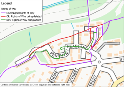
There were 148 orders, in some cases dating back to the 1950s, and the changes defined in these orders needed to be made to the map layer. The order documents were all scanned, and the map layer edited as appropriate. Due to the nature of the source material, it was not possible to register the scanned order plans and directly trace over them, so the updates were plotted relative to the modern Ordnance Survey MasterMap cartography. In some cases the original plans were unclear, particularly where other landmarks had changed over time, and significant interpretation was needed to create an accurate reflection of the true situation.
Once the map layer had been updated, the next stage of the project was to link the scanned orders to the CAMS records through LibraryLink. This enables officers at the council to instantly open the digital copy of the relevant legal order from the record of any of the paths affected, a valuable efficiency.
A final stage was to pass the scanned orders through Optical Character Recognition (OCR) software and extract the updates for the Definitive Statements. The extracted text was incorporated into the CAMS database.
Bridgend County Borough Council now have a CAMS solution with an accurate & up-to-date rights of way layer and integrated definitive statements and links to digital copies of the order paperwork.
Further information from Timothy Derbyshire