Between 2011 and 2013 Exegesis undertook phase 2 of a major project on Open Mosaic Habitats on Previously Developed Land (OMH), one of the outputs of which was a draft provisional inventory of OMH in England. Natural England subsequently contracted us three times in 2013 and 2014 to further refine the inventory, drawing upon the expertise we gained through the initial project.
 The work involved assessing data originally from the National Land Use Database of Previously Developed Land, British Geological Society BRITPITS data and Environment Agency Historic Landfill data. Each feature was interpreted on aerial photography to determine whether OMH was likely to be present. Where OMH was not thought to be present the feature was removed from the inventory. Where OMH was thought to be present the feature was replaced with an accurately mapped boundary. Attributes were recorded for each retained feature detailing the sources of information, the confidence that OMH was present and notes describing the reasons for any uncertainty.
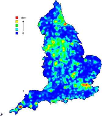
The result was the first ever inventory that separated OMH from brownfield sites more generally. In total 141,153 features were checked, but only 8,410 (32,602 hectares) of these were believed to be possible OMH and were therefore retained in the inventory. Greater London was shown to have the highest density of possible OMH, though Middlesbrough and St Austell in Cornwall were also found to be hotspots (shown above).
The process of inventory creation and the results were recorded in a rule base and project report.
Further information from Claire Lush.