For this project, we developed a new mapping system to display marine spatial data. It replaces an existing application (also developed by ESDM) that JNCC had used for nearly ten years.
 The project outputs consisted of a web interface for configuring the mapper, a modern and feature-rich web application for displaying maps, and consultancy services to JNCC in managing their database and web mapping services.
The project drew on our knowledge of managing large spatial datasets, optimising web mapping services, familiarity with marine habitat classification systems, and expertise in creating interactive web mapping applications.
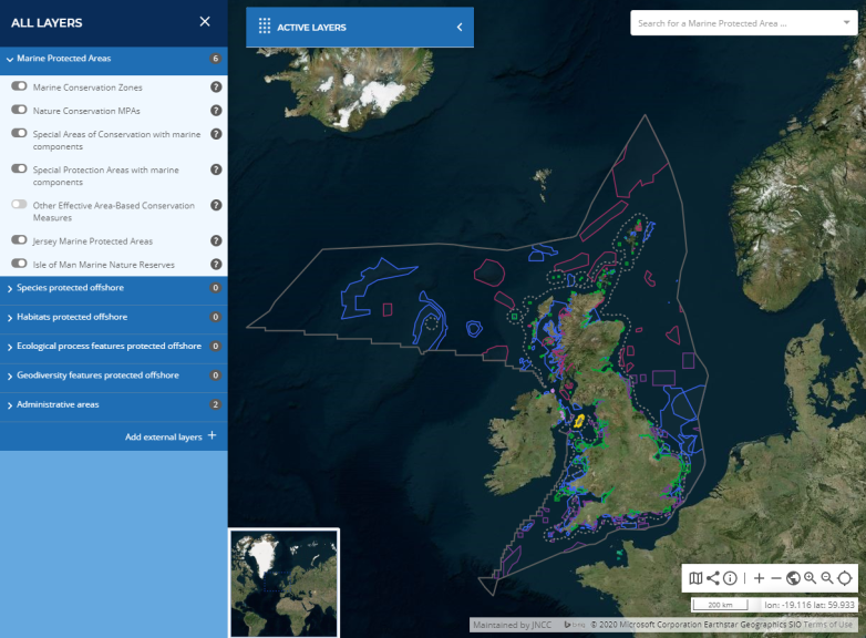
The new system is currently used to display marine protected area boundaries (MPAs) in UK waters by JNCC. It is also used for a diverse set of habitat and environmental variable datasets as part of the European Marine Observation and Data Network (EMODnet).
The mapper can be configured by JNCC staff, who decide which layers should be available, which are displayed by default, and how they may be filtered. It is not restricted to marine mapping and could be configured to display any tiled web mapping services.
Users of the map can search and browse layers, view information about specific habitats by clicking on the map, zoom to areas of interest using a gazetteer, change base maps, and filter layers for specific habitats for species. A permalink system allows users to save their current view of the map and share it with others via a URL.
The mapper is easily deployed and can run as a standalone application or it can be displayed within a content management system to maintain corporate identity. The styling of the mapper itself is customisable so that it can also be themed to meet the style guidelines of the hosting organisation.
This mapper has been one of several marine mapping web applications we have created over the last few years including the United Kingdom Directory of Marine Observing Systems (UKDMOS) ArcGIS desktop application and the Integrated Marine Data and Information System (iMarDIS) https://portal.imardis.org/.
Further information from Andy Brewer.